
Guide description
Mae Wong National Park (ÓĖŁÓĖĖÓĖŚÓĖóÓĖ▓ÓĖÖÓ╣üÓĖ½Ó╣łÓĖćÓĖŖÓĖ▓ÓĖĢÓĖ┤Ó╣üÓĖĪÓ╣łÓĖ¦ÓĖćÓĖüÓ╣ī) forms the border between Kamphaeng Phet and Nakhon Sawan and covers an area of about 894 square km.
Headquarters is located in northern parts of the park on the main road where some of the main attractions can be found. There are some basic accommodations with smaller rooms for rent as well as few camping grounds along the road for the visitors who wish to camp. The headquarters is 16.5km from nearby Khlong Lan town center where public buss services to and from Bangkok does operate several times a day.
The park offers many short, mid and longer trekking options with longest ones up to a week long journey deep into the heart of the jungle. Several of longer trails leads to waterfalls deep inside the jungle, but there are also few waterfalls easily accessible with up to a days return hiking.
Mae Wong is one of the best places in Thailand for birdwatching, home to many rare birds such as Rufous-necked Hornbill, Burmese Yuhina, Coral-billed Scimitar Babbler, Grey Peacock-pheasant, Mountain Hawk-eagle. According to some sources, 450 species of birds have been seen in the park including migratory species.
Camera traps from August 2011 released by DNP, Wildlife and Plant Conservation and WWF reveals that tigers are still around in Mae Wong, there are 9 tigers recorded. Some other exiting mammals that can be found in the park are Asian black bear, Phayre's leaf monkey, Golden Jackal, Lar Gibbon, and Malayan Tapir among many others.
Due to high altitude, the night temperatures may drop down to 8-9º C. Visitors are recommended to have sweaters with them.
Visitors are advised to have insect repellents and leach socks during wet periods. There are some annoying flies called "khun" in the local language, the bite from these can cause itchiness and biting marks.
Rainy season is June to October
Winter season with cooler weather is November to February
Summer (hot) season is March to May
Attractions of Mae Wong
Located 16.5 km from Khlong Lan town and 6 km from the checkpoint in the northwest there are some basic facilities such as shower, toilet, restaurant, parking area but also a cafeteria and a gift shop. There are bungalows with fan and hot water to accommodate group of 2 up to 9 persons each, smaller ones from 600B per night up to 2400B for larger ones (March 2014).
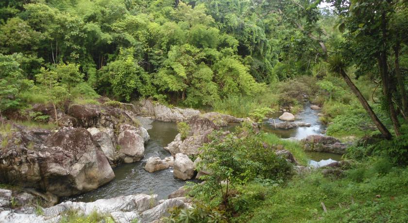
There is a campsite 400 m west from HQ nearby a smaller waterfall called Pa Nang Koy Waterfall, tents and accessories are available for rent from HQ. Another km west from the campsite there is an open place called Kaeng Pa Nang Roy Rapids, ideal for swimming and picnic.
Khun Nam Yen Campsite and Viewpoint
Located 3.7km from Chong Yen, and 24km from HQ. Compared to Chong Yen, there are a bit bigger and cleaner toilet and shower facilities in this campsite. There are no restaurants or rooms available.
The view point here has 360 degrees visibility at 1248m altitude, one of best in Thailand.
Chong Yen Campsite and Viewpoint
Chong Yen is a substation and campsite located at north west edge of the national park. It is on the end of main road (km 93), 27.5km from the headquarters.
The viewpoint 300-400m north is the highest peak of the road with an altitude of 1420m, a popular destination for local tourists. The campsite area is the main destination for the bird watchers within the national park.
Permission from HQ is needed to stay at Chong Yen, rooms can only be rented from HQ. There are no restaurants at the campsite, visitors should take food and necessary equipment with them. Toilet and shower facilities are very basic and may get a bit unpleasant during the week-ends when it is very busy.
There are couple of smaller trails around. The Umphang trail to south west leads all the way to Umphang town, the trail itself is an overgrown old road. We don't have information about the exact length, but we have been able to map 10.7km of it . Strict permission from HQ needed to walk this trail for a longer hiking.
Park rangers at Chong Yen regularly maintain few bird hiding spots where Grey Peacock-pheasant, Rufous-throated partridge and White-necked laughingthrush among some others can be seen regularly.
Khao Mokoju Summit
Located 38 km from the headquarters, it is the highest peak of the park at 1964 meters above sea level. 5-6 days round trip with park guides required to get there.
November to February is best time to see sea of mist from top of the summit, hills below covered in white mist creating a spectacular view.
Mae Kra Sa Waterfall
Formed by streams from Thanon Thong Chai mountain range with drop of 900 meters divided to 9 tiers. It is located 18km from park HQ, accessible by 3-4 days guided trekking.
Mae Gee Waterfall
With one tear over 200m high, one of highest waterfall in Southeast Asia. Mae Gee is originated from Tanon Thong Chai maountain range. It requires guided trekking.
Mae Rewa Waterfall
A 5 tiered waterfall with deep pools located about 21 km from the HQ. It requires 3 days guided return trekking.
Access price
Supplement per child : Ōé¼0 (ÓĖ┐0) (maximum of 0 childs)

