
Guide description
Lan Sang National Park (Thai: ÓĖŁÓĖĖÓĖŚÓĖóÓĖ▓ÓĖÖÓ╣üÓĖ½Ó╣łÓĖćÓĖŖÓĖ▓ÓĖĢÓĖ┤ÓĖźÓĖ▓ÓĖÖÓĖ¬ÓĖ▓ÓĖć) is in the Dawna Range, Tak Province, northern Thailand. Established in 1979, it is an IUCN Category II protected area measuring 104 square kilometres (40 sq mi). On the Tak-Mae Sot Highway in Mueang Tak District, it became the country's 15th national park.
Attractions
Lan Sang National Park covers an area of 65,000 rai. Various types of forest, such as rain forest, coniferous forest, hill evergreen forest, deciduous dipterocarp forest, and mixed deciduous forest, are found in different geographical areas. Wild animals found are common wild pig, barking deer, Siamese big-headed turtle, serow, civet, Black-crested Bulbul, and flying lizards
Namtok Pha Lat (ÓĖÖÓ╣ēÓĖ│ÓĖĢÓĖüÓĖ£ÓĖ▓ÓĖźÓĖ▓ÓĖö) This waterfall flows through a split-level hill of rocks down a broad complex ground of rocks. The ground slopes a bit and is 25 m wide and 40 m long.
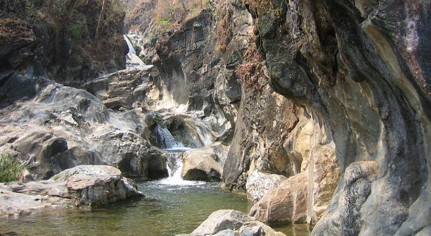
Namtok Lan Liang Ma (1st tier)(ÓĖÖÓ╣ēÓĖ│ÓĖĢÓĖüÓĖźÓĖ▓ÓĖÖÓ╣ĆÓĖźÓĖĄÓ╣ēÓĖóÓĖćÓĖĪÓ╣ēÓĖ▓ (ÓĖŖÓĖ▒Ó╣ēÓĖÖÓĖŚÓĖĄÓ╣ł Ó╣æ) It features a small rocky hill with a hole of around 6 m wide in the middle. The currents of Lam Huai Lan Sang pass through the hole against the water surface below. The waterfall is around 5 m high.
Namtok Lan Sang (2nd tier) (ÓĖÖÓ╣ēÓĖ│ÓĖĢÓĖüÓĖźÓĖ▓ÓĖÖÓĖ¬ÓĖ▓ÓĖć)(ÓĖŖÓĖ▒Ó╣ēÓĖÖ Ó╣Æ) The water gushes from a crevice of the mountain and cascades in three tiers before flowing into a pond and falling down to Namtok Lan Liang Ma.
Namtok Pha Ngoep (3rd tier) (ÓĖÖÓ╣ēÓĖ│ÓĖĢÓĖüÓĖ£ÓĖ▓Ó╣ĆÓĖćÓĖ┤ÓĖÜ) (ÓĖŖÓĖ▒Ó╣ēÓĖÖ Ó╣ō) The waterfall is 19 m high and has water only in the rainy and cool seasons. A prominent feature is Pha Ngoep, a high steep cliff with angular crevices.
Namtok Pha Phueng (4th tier) (ÓĖÖÓ╣ēÓĖ│ÓĖĢÓĖüÓĖ£ÓĖ▓ÓĖ£ÓĖČÓ╣ēÓĖć) (ÓĖŖÓĖ▒Ó╣ēÓĖÖÓĖŚÓĖĄÓ╣ł Ó╣ö) The waterfall features a 30 m high-flat surface cliff with a slope of 70 degrees. The water of Huai Lan Sang overflows the top of this waterfall and spreads whitewater to flow along the cliff and lower small layers of rocks covering the broad area before falling down to the pond below.
Namtok Pha The (ÓĖÖÓ╣ēÓĖ│ÓĖĢÓĖüÓĖ£ÓĖ▓Ó╣ĆÓĖŚ) This one-tier waterfall features a steep cliff 25 m high. The water of Huai Lan Sang runs quickly through a small narrow channel towards the cliff top where the ground is abruptly low.
Namtok Pha Nam Yoi (ÓĖÖÓ╣ēÓĖ│ÓĖĢÓĖüÓĖ£ÓĖ▓ÓĖÖÓ╣ēÓĖ│ÓĖóÓ╣ēÓĖŁÓĖó) This waterfall flows through a narrow channel in layers down to a broad and very deep pond.
Namtok Tha Le (ÓĖÖÓ╣ēÓĖ│ÓĖĢÓĖüÓĖŚÓ╣łÓĖ▓Ó╣ĆÓĖźÓĖóÓ╣ī) This waterfall of 50 m high features a slope with water flowing in layers from a cliff.
Viewpoint (ÓĖłÓĖĖÓĖöÓĖŖÓĖĪÓĖ¦ÓĖ┤ÓĖ¦) The Lan Sang National Park has a viewpoint on the top of Khao Noi overlooking a vista of Tak town.
Access price
Supplement per child : Ōé¼0 (ÓĖ┐0) (maximum of 0 childs)

