
Description
County Wicklow (Irish: Contae Chill Mhantáin, [╦łk╔ön╦Āt╠¬╦Āe╦É ╦łç╔¬l╠¬╩▓ ╦łwan╦Āt╠¬╦Āa╦Én╩▓]) is a county in Ireland. The second last of the traditional 32 counties to be formed, as late as 1606, it is part of the Mid-East Region and is also located in the province of Leinster. It is named after the town of Wicklow, which derives from the Old Norse name Víkingaló, which means "Vikings' Meadow". Wicklow County Council is the local authority for the county. The population of the county is 142,332 according to the 2016 census.
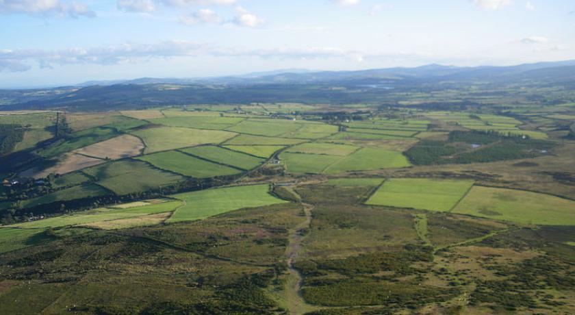
Wicklow is colloquially known as the Garden of Ireland. It is the 17th-largest of Ireland's 32 counties by area, being thirty-three miles in length by twenty miles in breadth, and 16th-largest by population. It is the fourth-largest of Leinster's twelve counties by size and the fifth-largest in terms of population. Between 2011 and 2016 the population of the county grew by 4.2%.
The boundaries of the county were extended in 1957 by the Local Government Act which "detached lands from the County of Dublin and from the jurisdiction and powers of the Council of the County of Dublin" near Bray and added them to the County of Wicklow. The adjoining counties are Wexford to the south, Carlow to the southwest, Kildare to the west and Dublin to the north.
Physical geography
Geology and mountains
The Wicklow Mountains range is the largest continuous upland region in Ireland. The highest mountain in the range, Lugnaquilla, rises to 925 metres (3,035 ft), making Wicklow the second-highest county peak after Kerry. The Wicklow Way is the oldest waymarked long-distance walking trail in Ireland, and the area is a popular attraction, as the region offers multiple choices of recreation including fishing before discharging into the Irish Sea at Arklow. The River Slaney is in the western part of the county, bordering County Carlow. The Turlough Hill pumped-storage scheme, a significant civil engineering project, was carried out in the mountains in the 1960s and 1970s. The lakes are small but numerous, located mainly in mountain valleys or glacial corries. They include Lough Dan, Lough Tay, Lough Brae, the lakes of Glendalough as well as the Poulaphouca reservoir (the largest by volume).
History
County Wicklow was the last of the traditional counties of Ireland to be shired in 1606 from land previously part of counties Dublin and Carlow. Established as a distinct county, it was aimed at controlling local groups such as the O'Byrnes. The Military Road, stretching from Rathfarnham to Aghavannagh crosses the mountains, north to south, was built by the British Army to assist them in defeating the rebels still active in the Wicklow Mountains following the failed 1798 rebellion. It provided them with access to an area that had been a hotbed of Irish rebellion for centuries. Several barracks to house the soldiers were built along the route and the Glencree Centre for Peace and Reconciliation was built alongside the remains of barracks there. Battalions of the Irish Army use firing ranges in County Wicklow for tactical exercises, especially the largest one in the Glen of Imaal which was previously used by the British Army prior to independence.
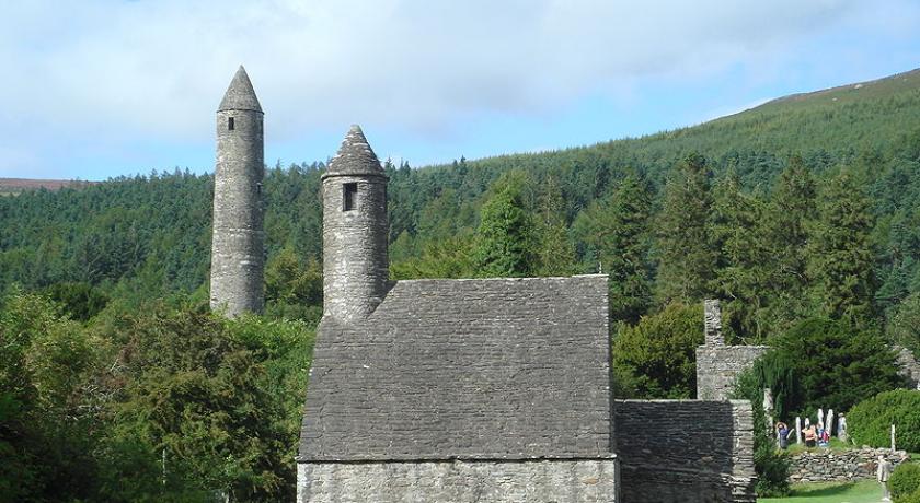
The ancient monastery of Glendalough is located in County Wicklow. During the Cromwellian invasion of Ireland, local authorities immediately surrendered without a fight. During the 1798 rebellion, some of the insurgents took refuge in the Wicklow Mountains, resulting in clashes between British troops and the troops commanded by General Joseph Holt (1756–1826) near Aughrim and later at Arklow.
Local government and politics
The local government authority is Wicklow County Council which returns 32 councillors from five municipal districts (Arklow, Baltinglass, Bray, Greystones, Wicklow). All of the previous Town Councils (Arklow, Bray, Greystones, Wicklow) were abolished under a new Local Government Act at the 2014 Local Elections. For elections to Dáil Éireann, the entire county in included in the Wicklow constituency along with some eastern parts of County Carlow. The constituency returns five TDs to the Dáil.
Dáil Éireann deputies
County Council councillors
Culture
Mermaid, County Wicklow Arts Centre is based in Bray. Mermaid is the county's hub of artistic activity and creation, offering a programme in many art forms: visual arts, theatre productions, opera, dance performances, arthouse cinema, comedy and a music programme. Two of the county's festivals take place in Arklow, the Arklow music Festival and the Arklow Seabreeze Festival.
The county is a popular film-making location in Ireland. Bray is home to Ardmore Studios, where many of Ireland's best known feature films, including Rawhead Rex John Boorman's Excalibur and Zardoz, Jim Sheridan's Oscar-winning In the Name of the Father, and several Neil Jordan films, have been shot. The BBC series Ballykissangel was also filmed in County Wicklow. Scenes from the movie P.S. I Love You were shot in the Wicklow Mountains National Park while several scenes from other movies, from Barry Lyndon to Haywire, have been filmed in the county.
Source: https://en.wikipedia.org/wiki/County_Wicklow
Address
County Wicklow
Ireland
Lat: 52.979862213 - Lng: -6.048263073

