

Description
Santorini, is an island in the southern Aegean Sea, about 200 km (120 mi) southeast of Greece's mainland. It is the largest island of a small, circular archipelago which bears the same name and is the remnant of a volcanic caldera. It forms the southernmost member of the Cyclades group of islands, with an area of approximately 73 km2 (28 sq mi) and a 2011 census population of 15,550. The municipality of Santorini includes the inhabited islands of Santorini and Therasia and the uninhabited islands of Nea Kameni, Palaia Kameni, Aspronisi, and Christiana. The total land area is 90.623 km2 (34.990 sq mi). Santorini is part of the Thira regional unit.
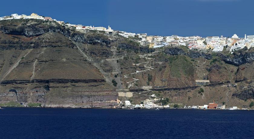
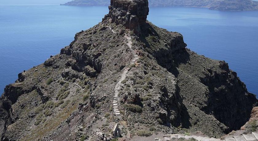
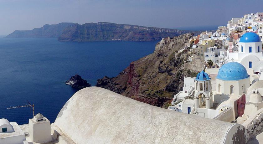
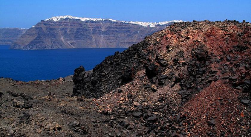
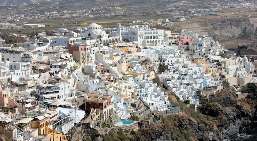
Santorini is essentially what remains after an enormous volcanic eruption that destroyed the earliest settlements on a formerly single island, and created the current geological caldera. A giant central, rectangular lagoon, which measures about 12 by 7 km (7.5 by 4.3 mi), is surrounded by 300 m (980 ft) high, steep cliffs on three sides. The main island slopes downward to the Aegean Sea. On the fourth side, the lagoon is separated from the sea by another much smaller island called Therasia; the lagoon is connected to the sea in two places, in the northwest and southwest. The depth of the caldera, at 400m, makes it impossible for any but the largest ships to anchor anywhere in the protected bay; there is also a fisherman's harbour at Vlychada, on the southwestern coast. The island's principal port is Athinios. The capital, Fira, clings to the top of the cliff looking down on the lagoon. The volcanic rocks present from the prior eruptions feature olivine, and have a small presence of hornblende.
It is the most active volcanic centre in the South Aegean Volcanic Arc, though what remains today is chiefly a water-filled caldera. The volcanic arc is approximately 500 km (310 mi) long and 20 to 40 km (12 to 25 mi) wide. The region first became volcanically active around 3–4 million years ago, though volcanism on Thera began around 2 million years ago with the extrusion of dacitic lavas from vents around the Akrotiri.
The island is the site of one of the largest volcanic eruptions in recorded history: the Minoan eruption (sometimes called the Thera eruption), which occurred some 3,600 years ago at the height of the Minoan civilization. The eruption left a large caldera surrounded by volcanic ash deposits hundreds of metres deep and may have led indirectly to the collapse of the Minoan civilization on the island of Crete, 110 km (68 mi) to the south, through a gigantic tsunami. Another popular theory holds that the Thera eruption is the source of the legend of Atlantis.
Modern Santorini
Tourism
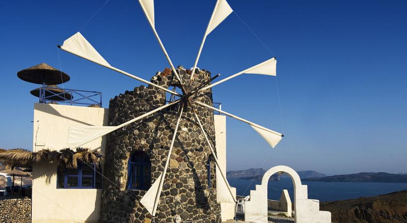
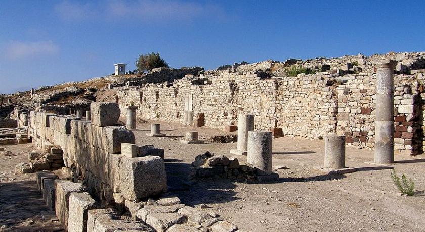
The 1956 Amorgos earthquake resulted in the demolishing of many buildings in the north of Santorini, leading to the desertion of many of its villages. The expansion of tourism has resulted in the growth of the economy and population. The major settlements include Fira (Phira), Oia, Emporio, Kamari, Perissa, Imerovigli, Pyrgos, and Therasia. Akrotiri is a major archaeological site, with ruins from the Minoan era. Santorini's primary industry is tourism, particularly in the summer months. In 2007, the cruise ship MS Sea Diamond ran aground and sank inside the caldera. The island's pumice quarries have been closed since 1986, in order to preserve the caldera. Santorini was ranked the world's top island for many magazines and travel sites, including the Travel+Leisure Magazine, the BBC, as well as the US News.
Aridity
Santorini has no rivers, and water is scarce. Until the early 1990s locals filled water cisterns from the rain that fell on roofs and courts, from small springs, and with imported assistance from other areas of Greece. In recent years a desalination plant has provided running, yet non-potable, water to most houses. Since rain is rare on the island from mid-spring till mid-autumn, many plants depend on the scant moisture provided by the common, early morning fog condensing on the ground as dew.
Agriculture
Because of its unique ecology and climate, and especially its volcanic ash soil, Santorini is home to unique and prized produce. Santorini tomatoes are renowned; they are cherry tomatoes that are extremely tasty and sweet, and with an intensely red, staining colour. Santorini "fava" is a purée made of the hulled, then sun-dried, then boiled legume Lathyrus clymenum – not from the yellow split pea as in the rest of Greece. The white eggplants of Santorini are very sweet, with very few seeds, and can be eaten raw. The katsoúni is a unique local variety of large cucumber which, if left unpicked when green, turn yellow and acquire a sweet taste almost indistinguishable from that of melon.[43] Capers with their unique flavor are used in Greek salads and other local dishes.
Cuisine
Local specialties:
- Brantada – A local Santorinian fish dish. Cod fillet coated in a mixture of flour, water, salt and sometimes beer, normally served with garlic salad. The best place to try it is in some less touristic villages, like Exo Gonia.
- Koskosela (local Strapatsada)
- Santorinio Sfougato – A traditional Santorini dish. Ingredients: small zucchini, onions, extra virgin olive oil, flour, eggs, rosemary leaves or spearmint tea leaves or dill, xinomyzithra or other sour milk cheese or soft feta, naxos sweet gruyère, salt and fresh ground pepper, sweet peppers, sesame seeds.
- Tsounisti (Manestra)
- Fava – A local Santorini dish, originally made with the broad bean. Later on, the broad bean was replaced with an easier version, the yellow shelled lentil. Its name originates from the word "favus" which is the Latin word for broad beans.
- Melitinia (dessert) – Melitinia are cookies that are made for weddings, engagements and festivals. They are made of unsalted mitzithra cheese and yogurt and they also have a beautiful smell of mastic. They can be found in the traditional bakeries of Santorini.
- Tomatokeftdes – also known as tomato fritters, is made with Santorini cherry sized tomatoes. It is cooked in olive oil with onions, peppers, mint and other herbs.
Wine industry
The island remains the home of a small, but flourishing, wine industry, based on the indigenous grape variety, Assyrtiko, with auxiliary cultivations of two other Aegean varietals, Athiri and Aidani. The vines are extremely old and resistant to phylloxera (attributed by local winemakers to the well-drained volcanic soil and its chemistry), so the vines needed no replacement during the great phylloxera epidemic of the late 19th century. In their adaptation to their habitat, such vines are planted far apart, as their principal source of moisture is dew, and they often are trained in the shape of low-spiralling baskets, with the grapes hanging inside to protect them from the winds.
The viticultural pride of the island is the sweet and strong Vinsanto (Italian: "holy wine"), a dessert wine made from the best sun-dried Assyrtiko, Athiri, and Aidani grapes, and undergoing long barrel aging (up to twenty or twenty-five years for the top cuvées). It matures to a sweet, dark amber-orange, unctuous dessert wine that has achieved worldwide fame, possessing the standard Assyrtiko aromas of citrus and minerals, layered with overtones of nuts, raisins, figs, honey and tea.
White wines from the island are extremely dry with a strong, citrus scent and mineral and iodide salt aromas contributed by the ashy volcanic soil, whereas barrel aging gives to some of the white wines a slight frankincense aroma, much like Vinsanto. It is not easy to be a winegrower in Santorini; the hot and dry conditions give the soil a very low productivity. The yield per acre is only 10 to 20% of the yields that are common in France or California. The island's wines are standardised and protected by the "Vinsanto" and "Santorini" OPAP designations of origin.
Architecture
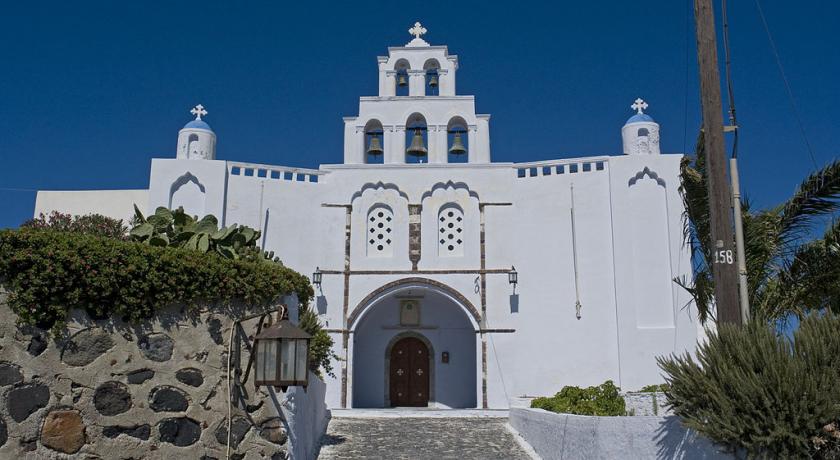
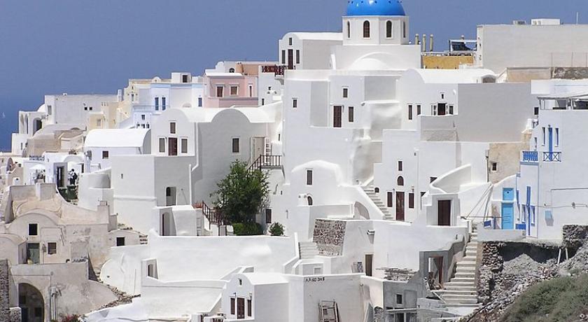
The traditional architecture of Santorini is similar to that of the other Cyclades, with low-lying cubical houses, made of local stone and whitewashed or limewashed with various volcanic ashes used as colours. The unique characteristic is the common utilisation of the hypóskapha: extensions of houses dug sideways or downwards into the surrounding pumice. These rooms are prized because of the high insulation provided by the air-filled pumice, and are used as living quarters of unique coolness in the summer and warmth in the winter. These are premium storage space for produce, especially for wine cellaring: the Kánava wineries of Santorini.
When strong earthquakes struck the island in 1956, half the buildings were completely destroyed and a large number suffered repairable damage. The underground dwellings along the ridge overlooking the caldera, where the instability of the soil was responsible for the great extent of the damage, needed to be evacuated. Most of the population of Santorini had to emigrate to Piraeus and Athens
Transport
Land
Bus services depart from Fira to most parts of the island.
Ports
Santorini has two ports: Athinios (Ferry Port) and Skala (Old Port). Cruise ships anchor off Skala and passengers are transferred by local boatmen to shore at Skala where Fira is accessed by cable car, on foot or by donkey. Tour boats depart from Skala for Nea Kameni and other Santorini destinations.
Airport
Santorini is one of the few Cyclades Islands with a major airport, which lies about 6 km (4 mi) southeast of downtown Thera. The main asphalt runway (16L-34R) is 2,125 metres (6,972 feet) in length, and the parallel taxiway was built to runway specification (16R-34L). It can accommodate Boeing 757, Boeing 737, Airbus 320 series, Avro RJ, Fokker 70, and ATR 72 aircraft. Scheduled airlines include the new Olympic Air, Aegean Airlines, Ryanair and Athens Airways, with chartered flights from other airlines during the summer, and with transportation to and from the air terminal available through buses, taxis, hotel car-pickups and rental cars.
History
Ancient and Medieval Santorini
Santorini remained unoccupied throughout the rest of the Bronze Age, during which time the Greeks took over Crete. At Knossos, in a LMIIIA context (14th century BC), seven Linear B texts while calling upon "all the gods" make sure to grant primacy to an elsewhere-unattested entity called qe-ra-si-ja and, once, qe-ra-si-jo. If the endings -ia[s] and -ios represent an ethnic suffix, then this means "The One From Qeras[os]". If the initial consonant were aspirated, then *Qhera- would have become "Thera-" in later Greek. "Therasia" and its ethnikon "Therasios" are both attested in later Greek; and, since -sos was itself a genitive suffix in the Aegean Sprachbund, *Qeras[os] could also shrink to *Qera. An alternate view takes qe-ra-si-ja and qe-ra-si-jo as proof of androgyny, and applies this name by similar arguments to the legendary seer, Tiresias, but these views are not mutually exclusive. If qe-ra-si-ja was an ethnikon first, then in following him/her/it the Cretans also feared whence it came.
Probably after what is called the Bronze Age collapse, Phoenicians founded a site on Thera. Herodotus reports that they called the island Callista and lived on it for eight generations. In the 9th century BC, Dorians founded the main Hellenic city on Mesa Vouno, 396 m (1,299 ft) above sea level. This group later claimed that they had named the city and the island after their leader, Theras. Today, that city is referred to as Ancient Thera.
In his Argonautica, written in Hellenistic Egypt in the 3rd century BC, Apollonius Rhodius includes an origin and sovereignty myth of Thera being given by Triton in Libya to the Greek Argonaut Euphemus, son of Poseidon, in the form of a clod of dirt. After carrying the dirt next to his heart for several days, Euphemus dreamt that he nursed the dirt with milk from his breast, and that the dirt turned into a beautiful woman with whom he had sex. The woman then told him that she was a daughter of Triton named Kalliste, and that when he threw the dirt into the sea it would grow into an island for his descendants to live on. The poem goes on to claim that the island was named Thera after Euphemus' descendant Theras, son of Autesion, the leader of a group of refugee settlers from Lemnos.
The Dorians have left a number of inscriptions incised in stone, in the vicinity of the temple of Apollo, attesting to pederastic relations between the authors and their lovers (eromenoi). These inscriptions, found by Friedrich Hiller von Gaertringen, have been thought by some archaeologists to be of a ritual, celebratory nature, because of their large size, careful construction and – in some cases – execution by craftsmen other than the authors. According to Herodotus, following a drought of seven years, Thera sent out colonists who founded a number of cities in northern Africa, including Cyrene. In the 5th century BC, Dorian Thera did not join the Delian League with Athens; and during the Peloponnesian War, Thera sided with Dorian Sparta, against Athens. The Athenians took the island during the war, but lost it again after the Battle of Aegospotami. During the Hellenistic period, the island was a major naval base for Ptolemaic Egypt.
As with other Greek territories, Thera then was ruled by the Romans. When the Roman Empire was divided, the island passed to the eastern side of the Empire which today is known as the Byzantine Empire. According to George Cedrenus, the volcano erupted again in the summer of 727, the tenth year of the reign of Leo III the Isaurian. He writes: "In the same year, in the summer, a vapour like an oven's fire boiled up for days out of the middle of the islands of Thera and Therasia from the depths of the sea, and the whole place burned like fire, little by little thickening and turning to stone, and the air seemed to be a fiery torch."
After the Fourth Crusade, the "Franks" – i. e. Catholic Western Europeans – annexed the isle to the Duchy of Naxos and renamed it "Santorini", that is "Saint Irene". Santorini came under Ottoman rule in 1579. The island is still home to a Catholic community and the seat of a Catholic bishopric.
In the Greek State
Santorini became independent of Ottoman rule in 1821, during the Greek War of Independence, and was united with Greece in 1830 under the Treaty of London.
World War II
During the Second World War, Santorini was occupied in 1941 by Italian forces, and in 1943 by those of the Germans. In 1944, the German and Italian garrison on Santorini was raided by a group of British Special Boat Service Commandos, killing most of its men. Five locals were shot in reprisal, including the mayor.
Municipality
The present municipality of Thera (officially: "Thira", Greek: Δήμος Θήρας), which covers all settlements on the islands of Santorini and Therasia, was formed at the 2011 local government reform, by the merger of the former Oia and Thera municipalities.
Oia is now called a ΚοινÏŒτητα (community), within the municipality of Thera, and it consists of the local subdivisions (Greek: τοπικÏŒ διαμÎρισμα) of Therasia and Oia.
The municipality of Thera includes an additional 12 local subdivisions on Santorini island: Akrotiri, Emporio, Episkopis Gonia, Exo Gonia, Imerovigli, Karterados, Megalohori, Mesaria, Pyrgos Kallistis, Thera (the seat of the municipality), Vothon, and Vourvoulos.
Economy
Santorini's primary industry is tourism. The two main sources of wealth in Santorini are agriculture and tourism. In recent years, Santorini has been voted one of the world's most beautiful islands (2015 Travelers” Choice Awards Reader's Choice Awards, amongst others).
Santorini remains the home of a small, but flourishing wine industry, based on the indigenous Assyrtiko grape variety. White varieties also include Athiri and Aidani, whereas red varieties include mavrotragano and mandilaria.
Address
Santorini
Greece
Lat: 36.393157959 - Lng: 25.461509705

